- Call us Via Whatsapp: +84 (0) 832 126 699
4.9 stars on our site
(15,000 reviews)
- Monday - Sunday : 08:00 - 17:00
(15,000 reviews)

Imagine standing at the crest of a cloud-swirling pass, your chest heaving after a unrelenting 1,200-meter vertical climb. The crisp mountain air carries the sharp scent of wild pine, damp limestone, and woodsmoke from stilt houses dotting the valley below. As your heart rate gradually slows, you hear the faint metallic click of your bike’s rear cassette cooling in the breeze and the distant roar of a river cutting through deep canyons far beneath your tire tracks. Down below, a gray ribbon of asphalt twists through soaring karst spires, daring you to dive into the descent.
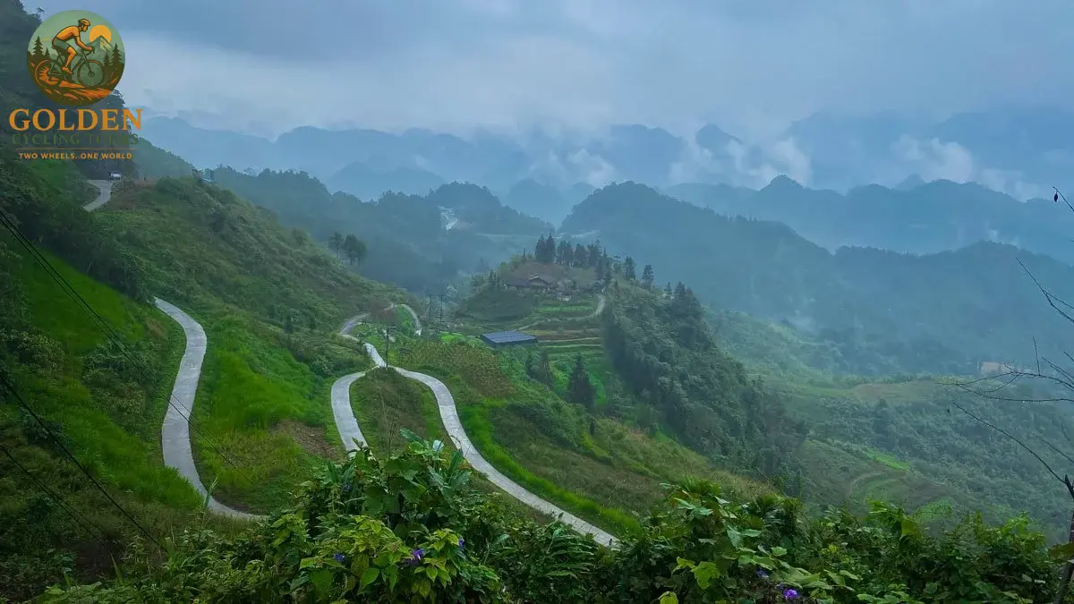
To ride through this jagged wonderland is to experience Asia at its most majestic and untouched. However, conquering these high-altitude corridors requires more than mere enthusiasm; it demands detailed planning and strategic insight. By studying Northern Vietnam Biking Maps: Elevation Profiles & Top Routes, cyclists can master these legendary alpine climbs, prepare for steep gradient shifts, and execute the ride of a lifetime.
Whether you are seeking the ultimate epic pass challenge or planning a smooth journey on modern electric bikes through verdant valleys, this complete guide provides the routes, elevation metrics, and regional wisdom necessary to master the northern frontier.
Understanding the terrain geometry of the northern mountains is crucial for a successful cycling expedition. When analyzing Northern Vietnam Biking Maps: Elevation Profiles & Top Routes, riders must look beyond flat mileage and focus on total vertical gain, average gradient, and mountain pass dynamics.
The geography of the northern region is defined by ancient limestone plateaus, fault lines, and river valleys that drop sharply into abyss-like canyons. A typical day in the saddle may span only 60 kilometers on the map, yet pack over 2,000 meters of total vertical climbing.
Climbs in this region rarely maintain a uniform pitch. Instead, they present steep 10% to 14% ramps interspersed with high-altitude false flats. Hairpin turns, locally called switchbacks, carve directly into vertical cliff faces. Mastering your cadence, pacing your energy, and understanding when to shift gears on these gradient spikes determines whether you glide over pass summits smoothly or exhaust your muscle reserves early.
Altitude profiles reveal the true difficulty of any bicycle journey. In the northern highlands, elevation ranges from near sea level in southern valleys up to 1,500 to 2,000 meters above sea level along high mountain ridges like Ma Pi Leng Pass and O Quy Ho Pass.
A well-mapped route profile highlights three vital metrics:
Cumulative Elevation Gain: The sum of every ascent made throughout the day.
Gradient Percentage: The steepness of the pitch, where anything over 8% demands low gear ratios and balanced body positioning.
Maximum Altitude: High elevations bring cooler temperatures, thinner air, and sudden shifts in mountain weather conditions.
By combining reliable GPS spatial maps with detailed altitude profile analysis, riders can pace their daily efforts, schedule hydration stops, and choose gear appropriate for every ridge and canyon.
From frontier border passes to peaceful rural valleys, the northern region offers world-class riding options. Explore the top routes that showcase the dramatic landscape of Cycling Northern Vietnam.
The high-altitude province of Ha Giang sits on the border with China and represents the pinnacle of mountain cycling in Southeast Asia.
Starting from the lowlands, the route ascends into the UNESCO-protected Dong Van Karst Plateau. The terrain features relentless climbs up Sky Gate Pass and Quan Ba Pass, culminating in the legendary Ma Pi Leng Pass. This cliff-hanging road ascends over 1,200 vertical meters, hovering above the emerald waters of the Nho Que River and the sheer drop-offs of Tu San Canyon.
To the west, the winding mountain roads of Hoang Su Phi cross steep, hand-carved rice terraces with technical gravel descents and continuous gradient shifts that test both stamina and bike handling skills.
Tackle this epic alpine loop on a professionally organized 10-day Ha Giang Loop & Hoang Su Phi Cycling Adventure or explore dedicated multi-day Ha Giang bike tours with full support vehicle back-up.
Located in the northeast, Cao Bang offers undulating terrain surrounded by sugarloaf limestone formations, pristine rivers, and ancient mountain forests.
This region features rolling hill profiles punctuated by moderate mountain passes like Khau Lieu Pass and Kolia Pass. Riders roll through scenic border sectors including Thong Nong and Quang Uyen before descending into the valley where the roaring Ban Gioc Waterfall thunderously straddles the frontier.
The route continues southwest through dense primary rainforests surrounding Ba Be National Park, where serene lakeside dirt tracks offer balanced riding without extreme high-altitude gradients.
Embark on the ultimate 15-day cross-regional journey via the 15-day Best of Northeast Vietnam Cycling Tour, explore targeted Cao Bang bike tours, relax around Ba Be Lake bike tours, or browse full regional itineraries with Vietnam Northeast bike tours.
For cyclists seeking smooth pedaling through emerald countryside, serene bamboo forests, and moderate rolling hills, the valley circuit southwest of Hanoi provides the perfect ride.
Beginning in the wide, peaceful basin of Mai Chau, the trail climbs gently over forested ridgelines into the protected bio-reserve of Pu Luong Nature Reserve. Here, singletrack pathways weave along ancient wooden waterwheels and cascading stream valleys.
The final leg glides eastward along flat, historic karst corridors into Ninh Binh and Tam Coc, where soaring limestone monoliths tower over quiet riverways and historic temples.
Experience these lush valleys on a classic 4-day Mai Chau to Pu Luong cycling adventure or customize your trip with Mai Chau bike tours and Pu Luong bike tours.
For those who want extra power on undulating terrain, book the premium 6-day Mai Chau, Pu Luong & Ninh Binh e-bike tour or select from modern Vietnam e-bike tours.
Choosing the right time of year ensures optimal road friction, clear visibility over mountain passes, and pleasant temperatures.
Autumn is widely considered the absolute best season for bicycle expeditions in the north. Monsoon rains clear away, revealing bright blue skies and crisp mountain air. Daily temperatures linger between 18°C and 26°C, creating perfect conditions for long hours in the saddle.
This window coincides with the breathtaking golden harvest across the terraced fields of Hoang Su Phi, Mu Cang Chai, and Mai Chau. The aroma of ripe mountain rice fills the valleys, while clear mountain views expand for miles across every summit.
Spring brings pleasant warmth and fresh plant life to the highlands. Temperatures are comfortable, and wild peach blossoms, plum blossoms, and yellow mustard flowers bloom across the rocky slopes of Dong Van Karst Plateau. The terraced fields fill with irrigation water, mirroring the morning sky like glass sheets framed by green cliffs.
Winter (December to February) brings cold mountain winds and low fog to high passes such as O Quy Ho Pass and Khau Pha Pass. Temperatures on pass summits can drop toward freezing, requiring thermal layers and strong headlamps.
Summer (June to August) brings heavy tropical warmth in the lower valleys and brief afternoon monsoon downpours. Flexible scheduling and support vehicles make summer cycling comfortable and manageable.
Planning your nutrition, evening rest, and transit ensures smooth execution across every stage of your ride.
Highland cuisine provides energy-dense nutrition using fresh local ingredients, bold herbs, and woodfire cooking techniques.
Highland Energy Specialties: Fuel up with bowls of hot Pho infused with star anise, charcoal-roasted mountain pork seasoned with wild mac khen pepper, stir-fried jungle ferns with garlic, and sticky rice baked inside bamboo trunks.
Where to Eat: Local market stalls in mountain towns like Dong Van, Meo Vac, and Cao Bang offer quick, hot broth and grilled skewers. In rural nature reserves like Pu Luong Nature Reserve, homestay hosts prepare delicious family feasts served on woven bamboo trays.
Resting your body after conquering vertical gains is vital for recovery.
Authentic Stilt Homestays: Stay inside wooden stilt houses built by Tay, White Thai, or Hmong families. Experience genuine hospitality, sleep beneath comfortable mosquito netting, and wake up to morning mists over green valleys.
Luxury Eco-Resorts: Riders seeking high-end pampering can enjoy eco-lodges featuring infinity pools overlooking deep valleys, full-service spa facilities for sore legs, and refined farm-to-table dining. Explore premium options at Vietnam luxury bike tours.
Transporting bikes to starting points from Hanoi requires proper care to protect rear derailleur hangers, hydraulic brake lines, and carbon frames. Dedicated support vehicles equipped with custom roof racks ensure your equipment arrives in top condition. Having a SAG-wagon support vehicle on standby allows you to rest during tough weather or gear up for steep sections whenever you wish.
The northern routes cross the ancestral homelands of over 30 distinct ethnic minority groups, including the Hmong, Dao, Tay, Nung, and White Thai communities.
Village Dress: Wear modest clothing when pedaling through rural villages or relaxing inside local homestays.
Photography Ethics: Ask for permission with a friendly smile or gesture before taking photos of elders, children, or local craftsmen.
Warm Hospitality: If invited to enjoy green tea or corn wine with your homestay hosts, accept with both hands as a polite sign of gratitude.
Here is what global cyclists say after navigating the high passes and valleys of the north:
"Studying the elevation profile of Ma Pi Leng Pass was intense, but actually pedaling it was pure magic. The views into Tu San Canyon were unreal, and having the support van from Golden Cycling Tours right behind gave me total confidence." – Julian M., New Zealand
"Riding an e-bike through Pu Luong Nature Reserve to Mai Chau was the highlight of our trip to Southeast Asia. The air smelled of wild forest herbs, the quiet mountain roads were incredible, and the local homestay dinners were unforgettable." – Sophie & Liam T., Canada
A lightweight gravel bike with wide tires (38c–45c) or a front-suspension hardtail mountain bike with low climbing gears is ideal. For long mountain passes, electric all-terrain bikes provide excellent assistance on steep climbs.
Highland routes in Ha Giang and Cao Bang require good physical stamina due to long gradients between 6% and 10%. However, with support vehicles, custom gear ratios, or modern e-bikes, riders of varying fitness levels can safely enjoy these iconic routes.
When booking a guided tour with Golden Cycling Tours, your heavy luggage travels inside the support van. You ride lightweight with only a small handlebar bag for essential personal items.
Major mountain passes are paved with smooth asphalt or concrete, though remote mountain links may feature short gravel patches or seasonal roadworks. Support vehicles shield riders and ensure quick assistance whenever needed.
While high-quality bikes are provided on guided tours, bringing your own clip-in pedals and familiar saddle ensures complete personal comfort over multi-day rides.

.jpg "Thai Binh Vietnam Bicycle")
.jpg "Phu Tho Vietnam Cycling")
.jpg "Thai Nguyen Cycling Vietnam")
.jpg "Tuyen Quang Cycling Vietnam")
.jpg "Vinh Phuc Cycling Vietnam")
Leave a Reply
Your email address will not be published. Required fields are marked *